Delve into the intricacies of [Drought Monitor Classification and Crop Moisture Assessments for Informed Agricultural Decision-Making] with an expert agricultural meteorologist. Unlock the secrets of the Drought Monitor, a powerful tool that classifies drought severity and guides proactive responses. By assessing crop moisture levels and understanding weather patterns, we empower farmers, government agencies, and water resource managers with the insights they need to safeguard agriculture and ensure food security.
Key Takeaways:

- The Drought Monitor classifies drought severity based on multiple factors, including weather patterns, soil moisture, and impact reports.
- Drought categories range from D0 (abnormally dry) to D4 (most intense).
- The Drought Monitor is created weekly by human experts, not computers.
- The map provides a national overview of drought, but local conditions may vary.
- Visit the U.S. Drought Monitor website for detailed information:
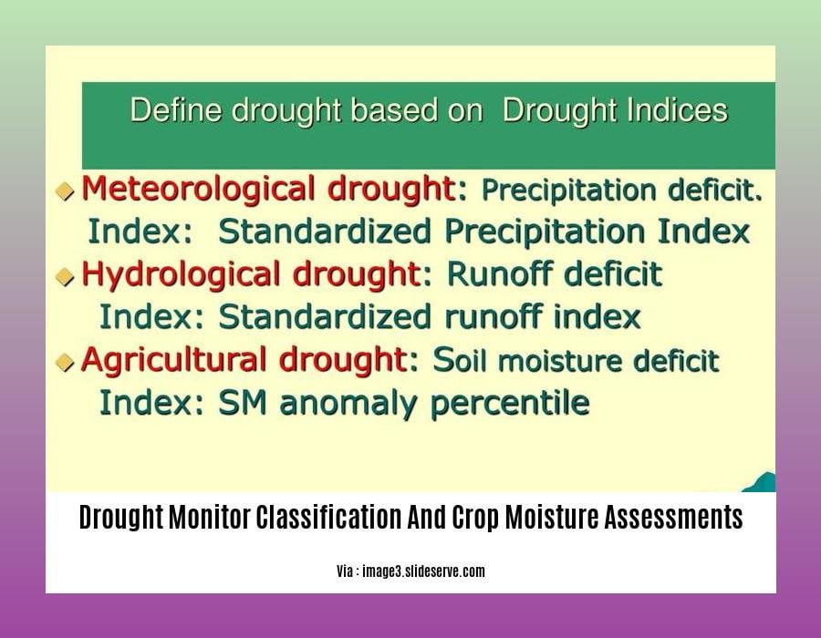
Drought Monitor Classification and Crop Moisture Assessments
The US Drought Monitor (USDM) is a collaborative effort between NOAA and USDA that tracks drought conditions across the country. It uses a variety of factors, such as precipitation, soil moisture, and reports of drought impacts, to categorize areas based on drought intensity. The USDM is updated weekly and provides a broad overview of drought conditions, but local conditions may vary.
The USDM uses a five-category system to classify drought intensity:
| Category | Description |
|---|---|
| D0 | Abnormally dry |
| D1 | Moderate drought |
| D2 | Severe drought |
| D3 | Extreme drought |
| D4 | Exceptional drought |
Crop moisture assessments are an important part of drought monitoring. They provide information about the amount of water available to crops and can help farmers make decisions about irrigation and other management practices. A variety of methods can be used to assess crop moisture, including soil moisture sensors, weather data, and satellite imagery.
How can drought monitor classification and crop moisture assessments support more informed agricultural decision-making?
Drought monitor classification can help farmers understand the severity of drought conditions in their area and make decisions about how to manage their crops. For example, farmers in areas experiencing moderate drought may need to start irrigating their crops more frequently, while farmers in areas experiencing severe drought may need to consider planting more drought-tolerant crops or fallowing their fields.
Crop moisture assessments can help farmers determine how much water their crops are receiving by factoring in data sources such as weather stations and soil moisture monitoring networks. This information can be used by farmers to optimize irrigation scheduling, conserve water, reduce crop stress, monitor crop yields, and make informed decisions about managing their water resources, and make informed decisions about irrigation and other management practices.
Drought monitor classification and crop moisture assessments are essential tools for agricultural decision-making. They can help farmers reduce the impacts of drought on their crops and improve their overall profitability.
For the latest updates on drought conditions and associated water restrictions in the region, click here: drought conditions and water restriction news
Discover how the drought has affected groundwater levels and wells across the state: drought impact on groundwater levels and wells
For a comprehensive guide to drought contingency planning for communities and local governments, visit: drought contingency planning for communities
Crop Moisture Assessments Using Soil Moisture Data
Crop-CASMA, a powerful tool in the realm of agricultural meteorology, has revolutionized the way we monitor crop conditions and soil moisture levels. This invaluable resource, developed through a collaborative effort between the USDA, George Mason University, and NASA, empowers farmers and agricultural experts with critical information to navigate the challenges posed by drought.
Soil moisture deficit, a silent yet formidable threat to crops, is a key indicator of agricultural drought intensity. Crop-CASMA harnesses the power of soil moisture data to provide timely and accurate insights into this crucial aspect of crop health. The tool seamlessly integrates data from diverse sources, including soil sensors, weather stations, and satellite imagery, to deliver a comprehensive snapshot of soil moisture conditions.
Key Takeaways:
- Crop-CASMA is an essential tool for monitoring crop conditions and soil moisture levels.
- Soil moisture deficit during the crop growing season is a telltale sign of agricultural drought.
- Crop-CASMA leverages multiple data sources to provide a comprehensive assessment of soil moisture conditions.
- The nonparametric index of soil moisture anomalies is a valuable metric for assessing agricultural drought.
Citation:
- Carrão, H., Russo, S., Sepulcre-Canto, G., & Barbosa, P. (2016). An empirical standardized soil moisture index for agricultural drought. Science of the Total Environment, 550, 836-844.
Remote Sensing and Crop Water Requirements
Remote sensing can continuously monitor crop water stress indicators, including canopy temperature, leaf area index, and vegetation indices. By analyzing these indicators, we can assess crop water demand and soil moisture availability. Extreme water stress can lead to crop damage or death, so timely monitoring and assessment are crucial.
Microwave remote sensing can measure soil moisture content, which is a key indicator of drought conditions. Machine learning can be combined with remote sensing to improve crop water stress detection, providing farmers with valuable information to guide irrigation scheduling and other management practices.
Key Takeaways:
- Remote sensing can continuously monitor crop water stress indicators.
- Crop water demand and soil moisture availability can be analyzed using these indicators.
- Extreme water stress can lead to crop damage or death.
- Microwave remote sensing can measure soil moisture content.
- Machine learning can be combined with remote sensing to improve crop water stress detection.
Citation:
– Carrão, H., Russo, S., Sepulcre-Canto, G., & Barbosa, P. (2016). An empirical standardized soil moisture index for agricultural drought. Science of the Total Environment, 550, 836-844.
Drought Mitigation and Preparedness Strategies
Drought can wreak havoc on crops, causing significant losses and economic strain. The US Drought Monitor and crop moisture assessments are powerful tools that provide crucial information for mitigating these impacts.
The US Drought Monitor: A Snapshot of Dryness
Imagine a map that depicts the severity of drought across the country, incorporating data on precipitation, soil moisture, and expert insights. That’s the US Drought Monitor, a weekly snapshot that helps farmers and water managers understand the extent and intensity of drought.
Crop Moisture Assessments: Water for Your Crops
Just like a thirsty plant, crops need adequate moisture to thrive. Crop moisture assessments provide essential information on water availability. Using soil sensors, weather data, and satellite imagery, these assessments track soil moisture levels, enabling farmers to make informed decisions about irrigation and crop selection.
Drought Mitigation and Preparedness Strategies
By understanding drought conditions and crop moisture levels, you can take proactive steps to minimize the impact of drought:
- Reduce Water Consumption: Implement water-saving irrigation practices like drip irrigation or mulching around plants to conserve moisture.
- Choose Drought-Tolerant Crops: Select crop varieties that are naturally more resistant to drought conditions.
- Monitor Soil Moisture: Regularly check soil moisture levels to determine when irrigation is necessary.
- Establish a Drought Plan: Develop a comprehensive plan that outlines specific actions to be taken during drought conditions, including water conservation measures and alternative water sources.
Key Takeaways:
- The US Drought Monitor tracks drought severity using objective data and expert insights.
- Crop moisture assessments provide information on water availability for crops.
- Drought mitigation strategies focus on reducing water consumption, selecting drought-tolerant crops, monitoring soil moisture, and establishing drought plans.
Citation:
- US Drought Monitor:

FAQ
Q1: How is the U.S. Drought Monitor classified?
A1: The U.S. Drought Monitor uses five categories to classify drought intensity based on a combination of objective physical indicators, local expert insights, and reports of drought impacts: Abnormally Dry (D0), Moderate (D1), Severe (D2), Extreme (D3), and Exceptional (D4).
Q2: What does the U.S. Drought Monitor indicate about crop moisture levels?
A2: The U.S. Drought Monitor provides a general overview of drought conditions, including information on crop moisture levels. Areas experiencing more severe drought conditions (D2 or above) are more likely to have significant crop moisture deficits.
Q3: How can farmers use the U.S. Drought Monitor to make informed decisions?
A3: Farmers can use the U.S. Drought Monitor to monitor drought conditions in their region and make informed decisions about crop management practices. For example, farmers in areas experiencing moderate drought (D1) may consider implementing irrigation strategies to mitigate the impacts on crop growth.
Q4: What other tools and resources are available to assess crop moisture levels?
A4: In addition to the U.S. Drought Monitor, there are various tools and resources available to assess crop moisture levels, including crop-specific moisture monitoring systems, soil moisture sensors, and satellite-based remote sensing data.
Q5: How can agricultural stakeholders enhance their resilience to drought conditions?
A5: Agricultural stakeholders can enhance their resilience to drought conditions by developing drought preparedness and mitigation strategies, implementing water conservation practices, utilizing drought-tolerant crop varieties, and engaging in collaborative efforts with experts and agencies to stay informed about drought conditions and best practices for mitigation.


